Most people who come to Picos de Europa simply stop by a couple of viewpoints, snap a few pictures of the Covadonga lakes, and then leave. Big mistake! Now that you’ve made your way here, there is at least one Lagos de Covadonga hike for every level, allowing everyone to experience the real magic of this beautiful alpine landscape. From short, family-friendly walks to full-day adventures, there’s something for all.
In this guide, you’ll find five different Lagos de Covadonga hikes for all levels. Let’s get those boots moving!
IMPORTANT: I’ve already covered all the viewpoints, transport and places to stay info in this Covadonga Lakes guide, so in this post, I’m just focusing on the hiking trails without diving into those places.

1. The Super Easy Hike: Lagos de Covadonga Loop
If you’re looking for an easy hiking trail in Lagos de Covadonga with good views, this one’s for you. The loop takes you around the two main lakes in the area—Enol and Ercina—but also includes other scenic highlights of Covadonga Lakes while steering clear of the most tourist-packed spots (especially in peak season).
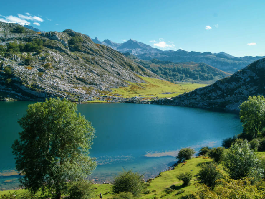
And here, easy doesn’t mean dull. The great thing about the Lagos de Covadonga is that you don’t have to venture far to soak in the scenery. Literally, as soon as you hit the road, you’ll start catching glimpses of the lakes, and the most accessible viewpoints offer fantastic views like this one 👇
Lagos de Covadonga Loop Hike info
The full loop is 6.5 km (4 miles) and very easy. But if you’re cider-hungover or just not in the mood for a long walk, there’s a shorter 3.5 km (2.2 miles) version. The longer route takes about 2 to 3 hours, tops.
The whole trail follows the PR-PNPE-2 path, which is well-marked and easy to walk.
Official Name: PR-PNPE-2
Distance: 4 miles (6.5 km)
Elevation gain: 86 meters (282 feet)
Difficulty: Easy
Duration: 2.5 – 3 hours
Trailhead
Most people start at the Buferrera parking lot, the main parking area where buses also drop off visitors. Trail maps and signs are available nearby to help you get your bearings.
Trail Description
From the parking lot, a wooden walkway leads up to the Pedro Pidal Visitor Center. Before continuing, take a super quick detour to the Mirador del Príncipe viewpoint. To be honest, this is the least impressive viewpoint you’ll see during the day, so it’s good that it’s at the beginning. Things only get better from here.
After the Visitor Center, the path continues towards the Buferrera Mines. A little further down, you’ll reach a small parking lot with a restaurant: Doña Rosa. They serve no-frills, good food at reasonable prices. It only opens during high season, though, and reservations are highly recommended—especially on weekends.
Right after the restaurant, you’ll reach the Entrelagos viewpoint, where you’ll get breathtaking views of Lake Enol on one side and Lake Ercina on the other. 90% of people don’t venture much further than this.

But since you’re still reading, I assume you’re part of the remaining 10% who actually use their legs—good on you! Keep walking past Lake Ercina, soaking in the unreal mountain backdrop. A little further on, you’ll reach Bricial, the third lake of Covadonga. It only appears after heavy rainfall or snowmelt, turning the valley into a temporary lake with a waterfall.
From here, just follow the path around the other side of Lake Enol, looping back to the parking lot. From this point on, you’ll start to encounter fewer people on the trail, but it’s perfectly safe. Here’s an image:

2. Easy Lagos de Covadonga Hike: Mirador del Rey
This easygoing trail is a great way to explore the area in just one morning. If you’re up for it, extend the hike by adding the loop, turning it into a 6-mile (10 km) Lagos de Covadonga hike, where you’ll enjoy the scenery from every angle.
Mirador del Rey Hike Info
Distance: 5 miles (8 km)
Elevation gain: 690 feet (210 meters)
Difficulty: Easy
Duration: 2 – 2.5 hours round hike
Trailhead
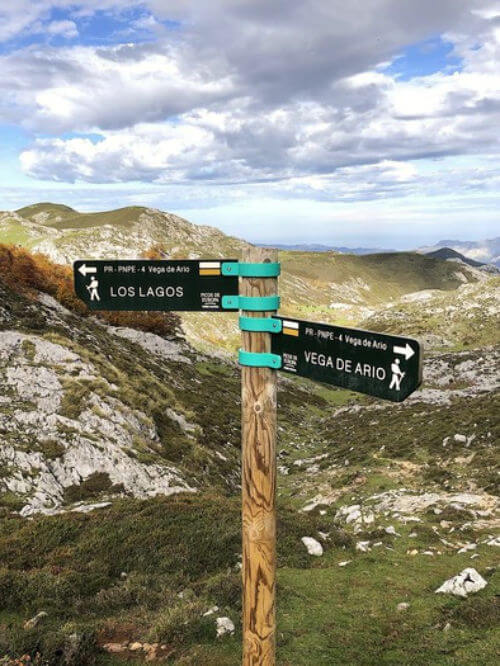
It starts near Lake Enol, following the same road used by buses from Cangas de Onís. Once at the lake, walk along its right-hand shore until you join the PR-PNPE2 trail, marked in yellow and white. No chance of getting lost—this is the only trail on this side of the lake.
Trail Description
Along the way, you’ll pass the Ermita del Buen Pastor on your left and, a bit further ahead, the Vega de Enol refuge down a short detour to the right. Stay on this path until it makes a sharp left turn. Instead of following it, take the dirt track straight ahead—it leads directly to Mirador del Rey.
3. Moderate Lagos de Covadonga Hike: Vega de Ario
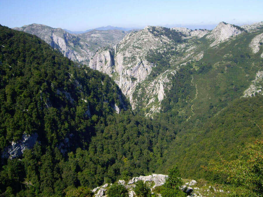
If you’re up for a solid but not too demanding day hike in Lagos de Covadonga, the trail to Vega de Ario is a great option. Along the way, you’ll get a different perspective of Lake Ercina, pass through green meadows, and patches of beech forests. The final part of the hike is a bit of a workout, with a well-earned reward at the end. The climb before reaching the mountain hut is short but steep—nothing too technical, just enough to get your heart pumping.
But the view up there is worth every step. The location of the Vega de Ario mountain hut is impressive, and on a clear day, you’ll have front-row seats to the peaks of the Western Massif in Picos de Europa.

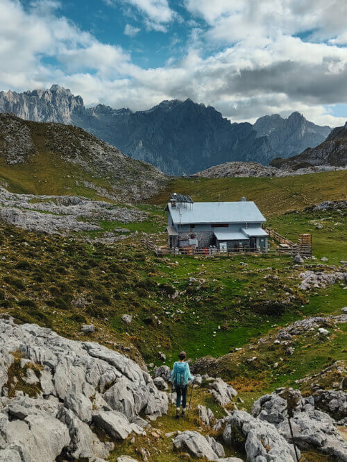
The hut is open from May to October. They serve up good food and drinks at surprisingly fair prices, considering you’re in the middle of nowhere. Perfect excuse for a break before heading back down!
Vega de Ario Hike Info
Official Name: PR-PNPE-2
Distance: 9.32 miles round hike (15 km)
Elevation gain: 1,740 feet (530 meters)
Difficulty: Moderate
Duration: 3 hours round hike
Trailhead
The trail starts at Lake Ercina (1,108m or 3,635 feet), on your left, heading southeast. It’s well-marked, and at first, it’ll lead you along the edge of the lake.
Trail Description
The path gradually climbs through a short gully called “La Cuenye” until you reach Los Bobias, a beautiful meadow with old shepherd huts. About 350 feet ahead (100 m), take a quick break under the shade of the beech trees and refill your water from the fountain. You’ll spot a hose above the trough. Just a heads-up—don’t drink directly from the trough unless you’re a cow!
From here, just follow the yellow-painted trail markers.
Before you reach the Vega de Ario hut, there’s a steep zigzag climb up to a col, where you’ll be rewarded with stunning views of the Picos de Europa Central Massif and a stone plaque marking all the peaks around you. If you take a small detour to the left (just 10 minutes on flat ground), you’ll reach the Vega de Ario refuge (1,634m or 5,364 feet).
4. Difficult Lagos de Covadonga Hike: Ordiales Lookout
The Ordiales Lookout is one of the most popular Lagos de Covadonga hikes.
Actually, this hike is not technically difficult, but it is long: it spans 14 miles in total (over 22 km), with an elevation gain of 3,000 feet (1,050 meters). It takes about 6.5 hours (round trip) at a normal pace. Not bad for a single day. Because of this, I recommend it only for those who are accustomed to mountain hiking and in good shape. But trust me, the stunning views of the Central Massif of the Picos de Europa are totally worth it.
Ordiales Lookout Hike Info
Distance: miles (21.5 km) round hike
Elevation gain: feet (900 meters)
Difficulty: Medium
Duration: 6,5 hours round hike
Trailhead
The trail to the Mirador de Ordiales from the Buferrera parking lot is the same as the one to Mirador del Rey. From Lake Enol, join the PR-PNPE2 trail, marked in yellow and white. Follow the signs for Refugio de Pastores.
Trail Description
After about a third of a mile (around 0.5 km), you’ll see a path to the right leading to the Enol lake refuge, but keep going left, which will take you to Pandecarmen, where you’ll find a parking lot. After about 4.3 miles (7 km), you’ll reach the Vegarredonda hut, where you can refill your water. This mountain hut offers food, drinks, and accommodations from May to October.
About 1.9 miles (3 km) further, you’ll finally arrive at the beautiful Mirador de Ordiales, a natural terrace at 5,741 feet (1,750 meters) above sea level. It’s probably one of the most stunning views in the Picos de Europa.
Pedro Pidal’s remains (the guy the visitor center is named after) are buried at the Mirador de Ordiales, where mountaineers carried them on September 18, 1949. His contributions to conservation earned him the honor of resting forever in the mountains he worked so hard to protect.

5. Challenging Lagos de Covadonga Hike: Jultayu Peak
Ready to take your adventure to the next level? If you’re up for a real challenge, I’ve got the perfect extension to your hike. Pico Jultayu towers above the Cares River gorge, offering jaw-dropping views of the Picos de Europa. But I won’t lie—it’s a tough hike for a single day.
If you’re visiting when the hut is open and have the time, I’d recommend splitting it into two days, with an overnight stay to fully enjoy the experience. Plus, the Vega de Ario hut is in a stunning spot, perfect for watching the sunset while sipping a well-deserved beer and having dinner. For a hut, food is surprisingly good!
Beds in the hut are limited, so it’s essential to make a reservation on the Vega de Ario official website.
Vega de Ario Hike Info
Distance: 13 miles (21 km) round hike
Total elevation gain: 4,430 feet (1,350 meters)
Difficulty: Difficult
Duration: 9 hours round hike
This route is for experienced trekkers only. Those low pastures with streams and families spending the day might be misleading, but once you gain some altitude, the Picos de Europa are no joke. You’ll need proper gear, a solid fitness level, and a sense of adventure. Once you pass the hut, the trail fades away, and you’ll need to scramble up some rocks.
Trailhead
The first part of the hike to Vega de Ario hut is the same as explained here. If you go between May and October, the refuge is open, so you can sleep there, grab a bite to eat or just leave your backpack there to make the climb to Jultayo a bit lighter and easier.

Trail Description
From the hut, head south, and the trail quickly leads into a rugged lapiaz. This karstic terrain, typical of the Picos de Europa, is made up of limestone rocks with deep grooves and gaps. You’ll need to keep an eye on your footing and do a bit of scrambling now and then. It’s not too difficult, but if you’re not experienced with this kind of terrain, take it slow. The good news is, the rocks have excellent grip.
There isn’t a marked path here, so keep an eye out for yellow paint marks on the rocks. The route zigzags upward to the summit. It’ll take about two hours from the refuge, depending on your pace. But trust me, the view from the top makes every step worth it.
The peak towers above a huge cliff, and below you, the Cares River gorge stretches out. Some say you can peek over the edge to see it, but I didn’t try—and I never will!


*Please note that these photos were taken in the middle of summer. If you go in winter or spring, everything will be covered in ice and snow, making things much more challenging.
After taking 120 photos in every possible pose, it’s time to retrace your steps back. I know, it’s not fun going back the same way you came, but the perspective changes a lot on the way down, so you definitely won’t get bored!
Hiking in the Picos de Europa: A Quick Guide
The Picos de Europa are mostly made of limestone, a rock that water slowly dissolves over time—hence the stunning karst landscape we see today.
A Brief Introduction to Picos de Europa
Over the years, water has carved out deep caves, sinkholes, and underground tunnels, while the surface is a dramatic mix of sheer cliffs and rugged terrain.
Ever noticed there are only a few lakes in the Picos? That’s because, up in the highlands, water seeps into cracks and disappears into a vast underground maze before resurfacing in springs and rivers like the Cares Gorge.
A guide once told me the Picos de Europa are like a giant Gruyère cheese—and honestly, he wasn’t wrong. While much of this hidden world remains unexplored, cavers have mapped over 400 km of caves, including 14% of the deepest shafts in the world.
Trails
The easiest trails are usually marked with signs and color-coded markers. But as you climb higher in the Picos, the terrain becomes more rugged and karstic. You’ll often find markings on rocks or cairns instead.

Wildlife
The Picos de Europa are home to several mammals, including wild boars, roe deer, wolves, and brown bears (Europe’s version of the grizzly). Hikers and climbers rarely run into any of them—they’re usually pretty shy. If you do spot one, just leave them be and everything will be fine.
The only animals that might approach you are the chamois, often due to irresponsible people feeding them. Please don’t do this—it’s not good for them.
Elevation
The Picos de Europa aren’t super high (the highest peak is 2,650 meters), but they’re incredibly steep and dramatic. The peaks rise sharply, creating that jaw-dropping landscape.
What makes them even more impressive is how close they are to the sea (in some places, just 15 km away). This means some trails start at low altitudes, like just 150 meters above sea level, making for some serious elevation gain. For example, the hike to the Vega de Ario shelter from the Cares River has a 3,100-meter total elevation gain (10,171 feet) and a 1,600-meter total loss (5,249 feet). Definitely not for the faint-hearted!
Terrain and Geology
As I mentioned, the Picos are full of caves, cliffs, ravines, and sinkholes. That’s why it’s so dangerous to stray from marked trails—there are deep holes that can be hard to spot.
It’s also not safe to enter caves you don’t know. If you want to venture off the trails, always go with a guide.

Drinking Water
Tap water is safe to drink anywhere in Spain. However, in natural parks, the water from fountains comes directly from springs. This is considered agua sin tratar or agua sin potabilizar which means “untreated”.
This doesn’t mean it’s unsafe—it just means the water can’t be regularly tested for quality, so park authorities can’t officially label it as safe. That said, everyone drinks it without issue, and I’ve never heard of any problems.
⚠️ IMPORTANT
Do not confuse agua sin potabilizar with agua no potable. The first term means that no tests have been carried out to guarantee its potability, but there is no reason or evidence to suggest it’s unsafe. For example, spring water coming directly from the mountain at high altitudes.
However, agua no potable literally means NOT SAFE, likely because it has been tested and is known to be unsuitable for human consumption.
For more detailed information on regulations and safety, it’s always a good idea to check the Picos de Europa Natural Park official website. They’ll also post any specific warnings, like road closures or trail shutdowns due to safety concerns or maintenance.
I hope this guide helps you get even more out of your visit to Covadonga Lakes and Picos de Europa. These are the most popular Lagos de Covadonga hikes, but there are hundreds of trails to explore in this natural park. All you’ll need is some time, good boots, and plenty of energy!
Feel free to drop any questions, and we’ll do our best to help you with planning your hike.